Showing posts with label google maps. Show all posts

Tuesday, 22 May 2018

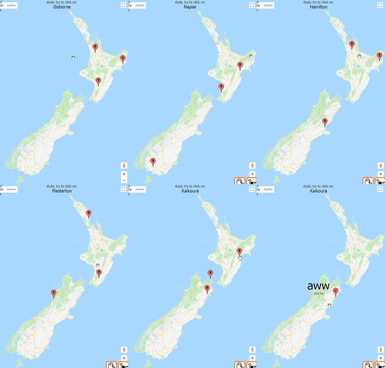
nz geohunter - game based on googlemaps api

A game based on googlemaps api.


The difficulty increases when you get three right in a row and decreases when you get one wrong. Harder = smaller population centers, easier = cities.

google maps - how to get co-ordinates for drawing buildings

This will let you draw shapes on the satellite picture and then output the lat lng coordinates of each point of the line. Those co-ordinates can then be saved and used by something else to draw shapes on maps.

This needs the drawing library! Make sure it is on the end of the link to the google maps api e.g. <script src="https://maps.googleapis.com/maps/api/js?key=YOUR_API_KEY&libraries=drawing">

Open up the dev tools and after drawing a rectangle, set of lines or a point it should output the co-ordinates to the console.

<body>
    <div id="map"></div>
    <script>

        function initMap() {
            var uluru = {
                lat: -39.072474,
                lng: 174.055992
            };
            var map = new google.maps.Map(document.getElementById('map'), {
                center: uluru,
                zoom: 17,
                mapTypeId: 'satellite'
            });
           
            // this creates the base options for the drawings (polygons/buildings)
            var drawingManager = new google.maps.drawing.DrawingManager({
                drawingMode: google.maps.drawing.OverlayType.MARKER,
                drawingControl: true,
                drawingControlOptions: {
                    position: google.maps.ControlPosition.TOP_CENTER,
                    drawingModes: ['marker', 'circle', 'polygon', 'polyline', 'rectangle']
                },
                markerOptions: {
                    icon: 'https://developers.google.com/maps/documentation/javascript/examples/full/images/beachflag.png'
                },
                rectangleOptions: {
                    fillOpacity: 0
                },
                circleOptions: {
                    //fillColor: '#ffff00',
                    fillOpacity: 1,
                    strokeWeight: 5,
                    clickable: false,
                    editable: true,
                    zIndex: 1
                }
            });
            drawingManager.setMap(map);

            // this just outputs the coordinates once a polygon is drawn on the screen
            google.maps.event.addListener(drawingManager, 'overlaycomplete', function (event) {
                console.log(event.type);
                if (event.type == 'rectangle') {
                    var ne = event.overlay.getBounds().getNorthEast();
                    var sw = event.overlay.getBounds().getSouthWest();

                    var bounds = "ne: " + ne.lat() + ", sw: " + sw.lat() + ", ne: " + ne.lng() + ", sw: " + sw.lng();
                    console.log(bounds);
                }
                if (event.type == 'polyline') {
                    //var radius = event.overlay.getRadius();
                    var coordinatesArray = event.overlay.getPath().getArray();
                    var allCoordinates = "";
                    for (var i = 0; i < coordinatesArray.length; i++) {
                        //console.log("new google.maps.LatLng(" + coordinatesArray[i].lat() + ", " + coordinatesArray[i].lng() + "),");
                        var coord = "{lat: " + coordinatesArray[i].lat() + ", lng: " + coordinatesArray[i].lng() + "},";
                        allCoordinates = allCoordinates + coord;
                    }
                    console.log(allCoordinates);
                }
                if (event.type == 'marker') {
                    var lat = event.overlay.getPosition().lat();
                    var lng = event.overlay.getPosition().lng();
                    var coord = "{lat: " + lat + ", lng: " + lng + "},";
                    console.log(coord);
                }
               
            });
        }
    </script>
    <script src="https://maps.googleapis.com/maps/api/js?key=[your key here]&libraries=drawing&callback=initMap" async defer></script>
</body>

wow. After you've got the coords and drawn some polygons based off them you can edit the lines by setting editable to true and adding a listener to the path you've created and output the new co-ordinates. This allows for fine tuning of the points of the polygon.

                // this is just used when editing the buildings - will output the new paths
                buildingDefinition.getPath().addListener('set_at', function(index, event) {
                    var coordinatesArray = this.getArray();
                    var allCoordinates = "";
                    for (var i = 0; i < coordinatesArray.length; i++) {
                        var coord = "{lat: " + coordinatesArray[i].lat() + ", lng: " + coordinatesArray[i].lng() + "},";
                        allCoordinates = allCoordinates + coord;
                    }
                    console.log(allCoordinates);
                });


HTML map of the hospital, using Google maps. This has a custom overlay (background) which shows the roads internal to the hospital. Different types of parking is hightlighed and bus stops and entrances to the hospital are shown. A list of services can be clicked on which will highlight the building they are in and center the map on that location.
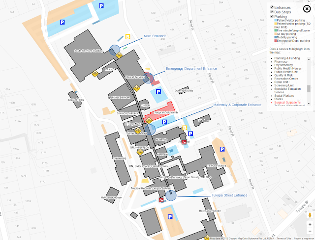


Clicking a building will show details:



Doing whatever:
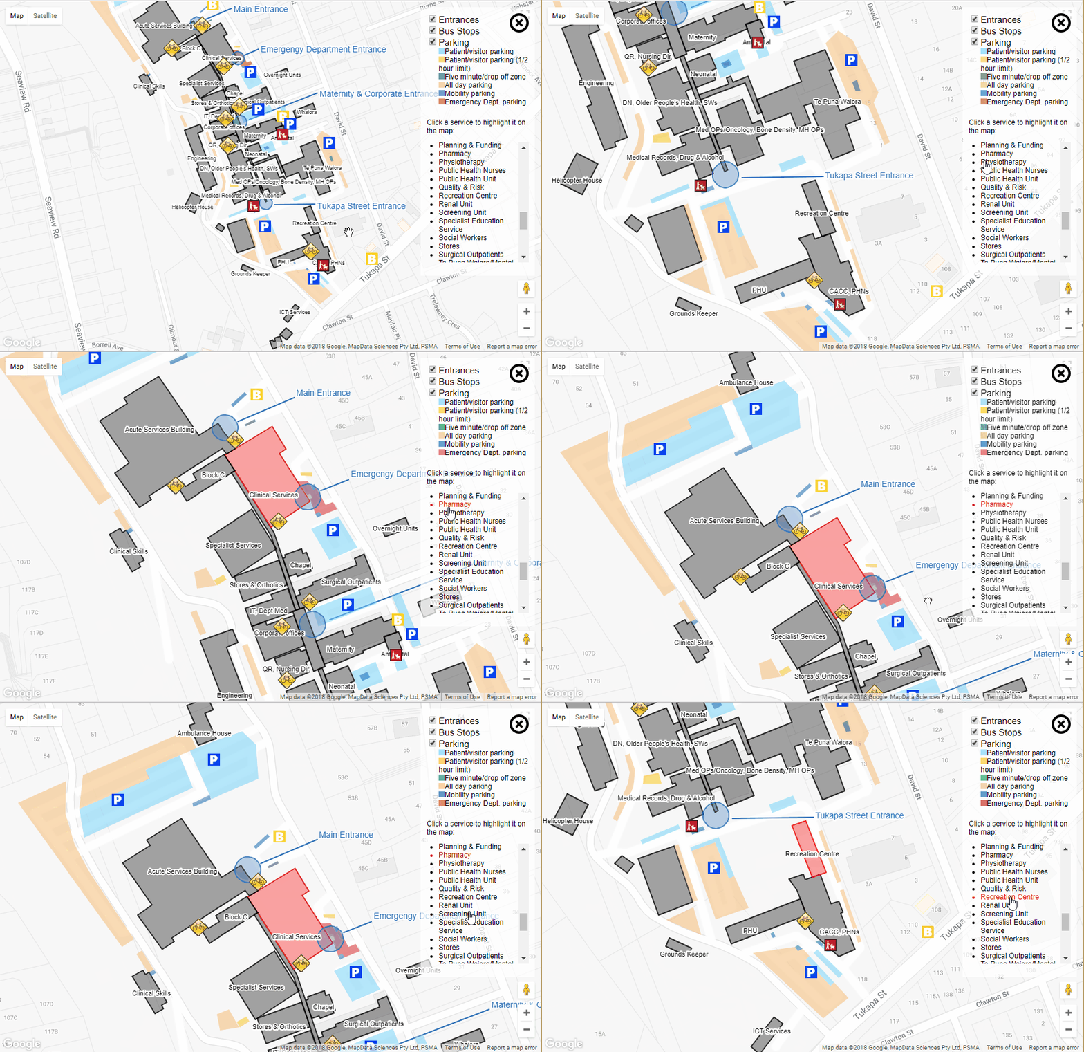


'Ambulance house' and 'Helicopter house' may or may not be the offical names of the buildings.

Building co-ordinates are stored in this format in sepearte js files:
var buildings = [];
var ict = {
    title: "ICT Services",
    key: "itServices",
    titleCoordinates: { lat: -39.0747770079001, lng: 174.0569919347763 },
    description: "Applications, Business Intellignence, Reporting and Development",
    coordinates: [{
        lat: -39.07470621091739,
        lng: 174.05701607465744
    }, {
        lat: -39.07475202073784,
        lng: 174.0570965409279
    }, {
        lat: -39.074962329077316,
        lng: 174.05688732862473
    }, {
        lat: -39.07491027261602,
        lng: 174.0568122267723
    }]
}

buildings.push(ict);
etc - add more buildings as required

This mob of co-ordinates is just referenced in the HTML
    <script type="text/javascript" src="buildingPersistance.js"></script>
    <script type="text/javascript" src="otherPersistance.js"></script>

Ok.
You have to sign up with google api and get a map key. Cram the script tag in your html:

    <script src="https://maps.googleapis.com/maps/api/js?key=[your key here]"></script>

Hook up an initialisation method to run when the maps stuff is loaded

        google.maps.event.addDomListener(window, 'load', initMap);

You need an initialisation method

        function initMap() {
            var uluru = {
                lat: -39.072474,
                lng: 174.055992
            };
            map = new google.maps.Map(document.getElementById('map'), {
                center: uluru,
                zoom: 17,
                styles: [{
                    featureType: 'poi',
                    stylers: [{
                        visibility: 'off'
                    }]
                }, {
                    featureType: 'transit',
                    elementType: 'labels.icon',
                    stylers: [{
                        visibility: 'off'
                    }]
                }]
            });

            // draw any buildings we have
            drawBuildings(map, buildings);
etc ...

When creating the map object the center will set the start location of the map
Styles defines what objects you want to show on the map (a heap of stuff shows by default)

Draw the things you want

        function drawBuildings(map, buildings) {
            for (var i = 0; i < buildings.length; i++) {
                var building = buildings[i];
                var buildingCoords = [];
                for (var c = 0; c < building.coordinates.length; c++) {
                    var coordinate = building.coordinates[c];
                    buildingCoords.push(new google.maps.LatLng(coordinate.lat, coordinate.lng));
                }
                var strokeColor = building.strokeColor ? building.strokeColor : '#000';
                var fillColor = building.fillColor ? building.fillColor : '#000';
                var buildingDefinition = new google.maps.Polygon({
                    paths: buildingCoords,
                    draggable: false,
                    editable: false,
                    strokeColor: strokeColor,
                    strokeOpacity: 0.8,
                    strokeWeight: 2,
                    fillColor: fillColor,
                    fillOpacity: 0.35,
                    originalStrokeColor: strokeColor,
                    originalFillColor: fillColor,
                    key: building.key,
                    description: building.description,
                    title: building.title
                });
                buildingDefinition.setMap(map);


Adding a popup for a building

                // build the popup information if we have a description for this building
                if (buildingDefinition.description) {
                    buildingDefinition.addListener('click', function(event) {
                        var contentString = '<div class="info-list-title">' + this.title + "</div>" + this.description;
                        infowindow.setContent(contentString);
                        infowindow.setPosition(event.latLng);
                        infowindow.open(map);
                    });
                }

Creating a label for a building (using maplabel-compiled.js from ... somewhere?)

                // create a label for this building
                if (building.title && building.titleCoordinates) {
                    var mapLabel = new MapLabel({
                        text: building.title,
                        position: new google.maps.LatLng(building.titleCoordinates.lat, building.titleCoordinates.lng),
                        map: map,
                        fontSize: 9
                    });
                    mapLabels.push(mapLabel);
                }